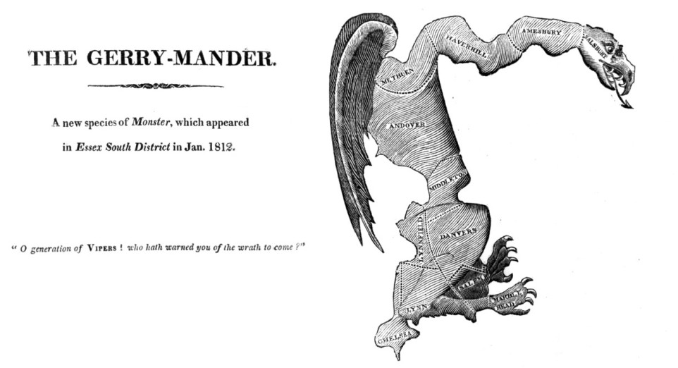
The act of gerrymandering acquired its name in 1812, when Massachusetts governor Elbridge Gerry approved a state redistricting plan that favored his own party. The partisanship of the map was manifest in the contorted shapes of its districts—one in particular, the story goes, reminded the editor of the Boston Gazette of a salamander, giving rise to a portmanteau that stuck: the gerry-mander.
The name was new, but the practice was not. By the time the case was making news, gerrymandering had long been an established fact of American politics. Even so, redistricting was a tedious process done entirely by hand. It involved a considerable amount of work: maps had to be drawn and redrawn, demographics had to be tallied and retallied, all within a short timeframe. It also required intricate knowledge of the electorate across the entire state.
Digital technology has revolutionized this process. As mathematician Jordan Ellenberg explained in a New York Times op-ed, “Gerrymandering used to be an art, but advanced computation has made it a science.” While drawing districts for partisan gain is an ancient custom in American politics, computers have greatly improved its effectiveness.
Digital technology has advanced to the point where carrying out a legal, effective, and durable gerrymander may hardly be more difficult that editing a picture in Photoshop. The consequences are troubling. Left unchecked, digital gerrymandering threatens to make competitive elections a thing of the past.
Packing and Cracking
To understand how gerrymandering works, consider a pile of stones, some blue and some red. You have to group the stones into as many piles of three as possible. But you want to arrange the piles so that blue wins—in other words, you want the maximum number of piles to have a majority of blue stones.
Suppose the pile has fifteen stones: nine red and six blue. Even though there are more red stones—red has a three-to-two advantage over blue—this is a combination that can nonetheless be grouped into piles of three so that blue has the overall majority. Forming groups of three blue stones must be avoided, for only two stones are required for blue to “win” a pile. Similarly, it is ill-advised to place a blue stone with two red ones: blue does not win that pile, so again a blue stone gets wasted. The optimal solution for a blue victory is to form three piles of two blue stones and one red stone, and two piles of three red stones.
This example captures the essence of gerrymandering. The strategies employed even have specific names: “packing” and “cracking.” “Packing” is when you concentrate the other party’s voters in certain districts—putting the red stones into two all-red piles. “Cracking” is when you dilute the other party’s electoral strength by distributing its voters across many districts—scattering the red stones into three blue-majority piles.
Block Party
Whenever you rearrange the stones, you have an opportunity to gerrymander. That happens every ten years, when states draw new Congressional and legislative districts. Redistricting immediately follows each national census, and it is designed to accommodate changing trends in population.
A district map is supposed to satisfy several—often conflicting—criteria, such as equal population, stipulations of the Voting Rights Act, respect for city boundaries, and fair representation for “communities of interest”—broadly defined as groups of individuals who have similar legislative concerns.
Meeting all of these requirements is highly challenging. As a result, redistricting is ultimately a matter of trial and error. Officials often have to test many different iterations of a district map until they find one with an acceptable approximation of the desired outcome.
To conceptualize the redistricting process, imagine that you have a paper map that shows the boundaries of various numerically-labeled “census blocks.” (A census block is the finest level at which census data is reported; in urban areas, it often corresponds to a city block.) You also have at hand the corresponding tabular demographic data—for instance, the race and gender breakdown, or the number of voting-age residents of voting age—referenced by block number.
Now imagine laying a sheet of tracing paper on top of the base map. On this layer, you are free to trace lines around groups of census blocks to form your own “districts.” You can use the census data tables, and some basic arithmetic, to find the demographic information specific to any given district—say, the number of voting-aged Latina women living there. This is the process of aggregating census data to the district level.
Visualizing census data by district is invaluable for drawing legal districts. But a gerrymanderer needs more than just census data—they also need to predict election results by census block. They need to know the color of the stones, in other words. Election results, however, are not reported by census block, and methods of collecting and tabulating election data vary greatly by state.
The Voting Tabulation District (VTD) is the Census Bureau’s general term for the “unit” at which election data is reported. A VTD might be a voting district, a ward, or a county, depending on the state. Fortunately, these VTDs are themselves built from census blocks, so that the process of integrating this data involves disaggregating the VTD election data into its constituent blocks.
Suppose that in a recent election, a VTD has a voting population of 1000. Of those voters, 600 voted for the Red Party, and 400 for Blue. If one census block within the VTD has ten residents of voting age, that block is projected to be worth six red votes and four blue—the same red-to-blue ratio as the entire VTD. If another census block from the same VTD has fifty voting-age residents, it is projected to be worth thirty red votes and twenty blue.
Repeating this process for every VTD gives each census block in the state its own weights of red and blue votes. This provides an approximation of historical election results at the census block level, which in turn predicts the block’s vote for future elections. The blue-biased gerrymanderer can then group census blocks into districts to maximize the number of projected blue wins, based on the election results that are disaggregated from VTD data.
Point and Click
Redistricting can be done by hand, but it’s time-consuming and difficult. Fortunately, it’s the sort of task that technology excels at—which is why officials now use standard commercial redistricting software when drawing districts. But the same features that make these applications useful for creating compliant districts are also what make them useful for gerrymandering.
Since the 2001 redistricting cycle, most states have used a GIS software package called Maptitude to draw their district maps. Maptitude has attracted the attention of state officials with its innovative capacity to handle the Census Bureau’s own digital geographic feature files. It also comes prepackaged with demographic census data, which it easily merges with any other data the user chooses to load into the program. The user then works with a layered map, where each layer corresponds to a different type of feature, such as a road or a political boundary—much like a digital version of the tracing paper scheme used to aggregate census data by hand.
Using Maptitude is comparable to using Photoshop. The user chooses a map layer—say, the counties layer. With a few clicks of the cursor over the map, the user selects a particular cluster of counties. The program automatically adds the boundary of the group to the working map layer as a new “district.” Statistics about the new district are instantly calculated from the available data and displayed in a table on the screen.
With this instant feedback, the user can then make small modifications to the boundary as needed. For instance, if the population of the district is slightly too small, the user can switch to the VTD layer and attach a single VTD to bump up the district size.
With software like Maptitude, redistricting becomes significantly easier—and so does gerrymandering.
Big Data Gerrymandering
Maptitude doesn’t just make it easier to work with census data, however. It also enables users to incorporate data from other sources that might be useful for gerrymandering. After all, in the age of big data, there is a broad spectrum of information available for purchase, some of which is overtly predictive of the voting behavior.
Credit card purchases can reveal membership in the NRA, regular donations to Planned Parenthood, or subscriptions to the National Review. Geopositioning software on personal devices is becoming more widespread, and often goes unnoticed by users. A geotagged photo taken at a white-supremacist rally, for instance, might reveal important data about that user’s political preferences.
All of this information could easily be loaded into Maptitude and used to draw gerrymandered districts. It should be emphasized that the use of this type of commercially available data for the purposes of gerrymandering is, to date, strictly hypothetical. However, so-called “data brokers” are already in the business of packaging vast bundles of data for the purposes of selling it to political parties for campaigns and fundraising. Using it for gerrymandering seems like a natural next step.
Algorithms used by tech companies to sell advertising already do an excellent job predicting consumer preferences. These same algorithms may be just as effective in predicting political preferences. The abundance of data—and the sophistication of the machine learning models that train on that data—make it possible to detect patterns in human behavior that would otherwise be invisible.
It’s not simply that algorithms are getting better at predicting behavior, however. It’s also that voting patterns are getting easier to predict, as the US electorate becomes increasingly polarized. An astonishing 66% of states are currently governed by a “trifecta,” in which both legislative chambers and the governorship are held by the same party—the vast majority by Republicans.
Trifectas tend to encourage gerrymandering. When a legislature knows the governor is unlikely to veto a district map—as when the map’s bias works in the governor’s favor—public officials are far more likely to attempt a bold gerrymander. This is precisely what happened in Wisconsin in its last redistricting process in 2011, which provoked a legal challenge now before the Supreme Court, Gill v. Whitford.
Drawing Better Shapes
Wisconsin’s gerrymandered map all but guarantees a permanent Republican majority, even though the state as a whole is evenly split between Democrats and Republicans. As part of their evidence in Gill v. Whitford, the plaintiffs have presented computer simulations that conclude that the map is an unmistakable statistical outlier, strongly suggesting that partisan interests were at play in its design.
In our current political environment, however, it was not entirely surprising that two Supreme Court justices, including Chief Justice Roberts, dismissed much of the work as “sociological gobbledygook” during oral arguments in October 2017. Stanford professor Jonathan Rodden, contributor to an amicus brief for the case, expressed his frustration to me in an interview: “There are so many things that we can do that are really rigorous and correct. But then you talk to a federal judge and they just look at you like you’re from Mars.”
The Supreme Court is expected to issue its ruling in June 2018, and the decision is likely to have significant impact on the future of gerrymandering. But Rodden suspects that the outcome of the Wisconsin case is not as earthshaking as some observers would like to believe. The courts aren’t a silver bullet when it comes to cracking down on gerrymandering—rather, different political approaches are needed.
For states that hold referenda, it may be possible to put measures on the ballot that hand the task of drawing districts to an independent commission. This was the path that California ultimately took to address its gerrymandering problem, a move widely acknowledged to have been successful. The state of Florida passed an amendment making gerrymandering explicitly unconstitutional, and it has been used to disqualify a biased district map.
But any enduring solution will require sustained civic engagement. You can’t force politicians to stop drawing maps that help them get elected without building popular pressure from below.
Maimuna Majumder, a graduate student at MIT and computational epidemiology research fellow at HealthMap, has observed a negative correlation between gerrymandering awareness and the presence of gerrymandering across the United States. The more people know about gerrymandering, in other words, the less it happens.
That creates a sense of urgency when it comes to raising awareness—particularly as gerrymandering becomes more effective with ever more granular data and ever more predictive algorithms. Our democracy depends on it.